
What topics and trends defined most-cited Land Use and Ecosystem Services research in the Class of 2026?
The Class of 2026 in Land Use and Ecosystem Services is dominated by remote sensing and urban heat island mitigation. While traditional urbanization studies have seen a decline, there is a marked shift toward advanced machine learning techniques, geospatial mapping, and thermal environment interventions.
At a glance
- Field
- Land Use and Ecosystem Services
- Cohort label
- Class of 2026 (2024 publications)
- Papers analyzed
- 12,996
- Papers ranked
- 20
- Top topics in ranked papers
- Remote sensing, Urban heat island (UHI), Land surface temperature
- Publication window
- Jan 1, 2024 – Dec 31, 2024
- Eligibility
- Research articles; reviews excluded
- Citation window
- 18 months post-publication
- 18m citation range
- 77–168
- Data source
- OpenAlex · Retrieved September 2026
- License
- CC BY 4.0
Rankings
20 papers ranked by 18-month citation count
GLC_FCS30D: the first global 30 m land-cover dynamics monitoring product with a fine classification system for the period from 1985 to 2022 generated using dense-time-series Landsat imagery and the continuous change-detection method
Earth system science data202410.5194/essd-16-1353-2024
Green spaces provide substantial but unequal urban cooling globally
Nature Communications202410.1038/s41467-024-51355-0
Global trends and scenarios for terrestrial biodiversity and ecosystem services from 1900 to 2050
Science202410.1126/science.adn3441
3D-GloBFP: the first global three-dimensional building footprint dataset
Earth system science data202410.5194/essd-16-5357-2024
Deep learning for urban land use category classification: A review and experimental assessment
Remote Sensing of Environment202410.1016/j.rse.2024.114290
Optimizing urban green space configurations for enhanced heat island mitigation: A geographically weighted machine learning approach
Sustainable Cities and Society202410.1016/j.scs.2024.106087
Effects of patterns of urban green-blue landscape on carbon sequestration using XGBoost-SHAP model
Journal of Cleaner Production202410.1016/j.jclepro.2024.143640
Mitigating urban heat island through neighboring rural land cover
Nature Cities202410.1038/s44284-024-00091-z
Revealing the impact of urban spatial morphology on land surface temperature in plain and plateau cities using explainable machine learning
Sustainable Cities and Society202410.1016/j.scs.2024.106046
Evaluating Eco-Efficiency as a metric for sustainable urban Growth: A comparative study of provincial capital cities in China
Ecological Indicators202410.1016/j.ecolind.2024.112959
Biodiversity loss reduces global terrestrial carbon storage
Nature Communications202410.1038/s41467-024-47872-7
Vertical canopy structure dominates cooling and thermal comfort of urban pocket parks during hot summer days
Landscape and Urban Planning202410.1016/j.landurbplan.2024.105242
Mixed effectiveness of global protected areas in resisting habitat loss
Nature Communications202410.1038/s41467-024-52693-9
Carbon storage through China’s planted forest expansion
Nature Communications202410.1038/s41467-024-48546-0
Machine Learning for Urban Heat Island (UHI) Analysis: Predicting Land Surface Temperature (LST) in Urban Environments
Urban Climate202410.1016/j.uclim.2024.101962
Conflation of reforestation with restoration is widespread
Science202410.1126/science.adj0899
Multi-temporal image analysis of wetland dynamics using machine learning algorithms
Journal of Environmental Management202410.1016/j.jenvman.2024.123123
Machine learning in modelling the urban thermal field variance index and assessing the impacts of urban land expansion on seasonal thermal environment
Sustainable Cities and Society202410.1016/j.scs.2024.105345
Global urban structural growth shows a profound shift from spreading out to building up
Nature Cities202410.1038/s44284-024-00100-1
Monitoring landuse change in Uchhali and Khabeki wetland lakes, Pakistan using remote sensing data
Gondwana Research202410.1016/j.gr.2023.12.015
Topic trends
Dominant research themes and year-over-year shifts in Land Use and Ecosystem Services
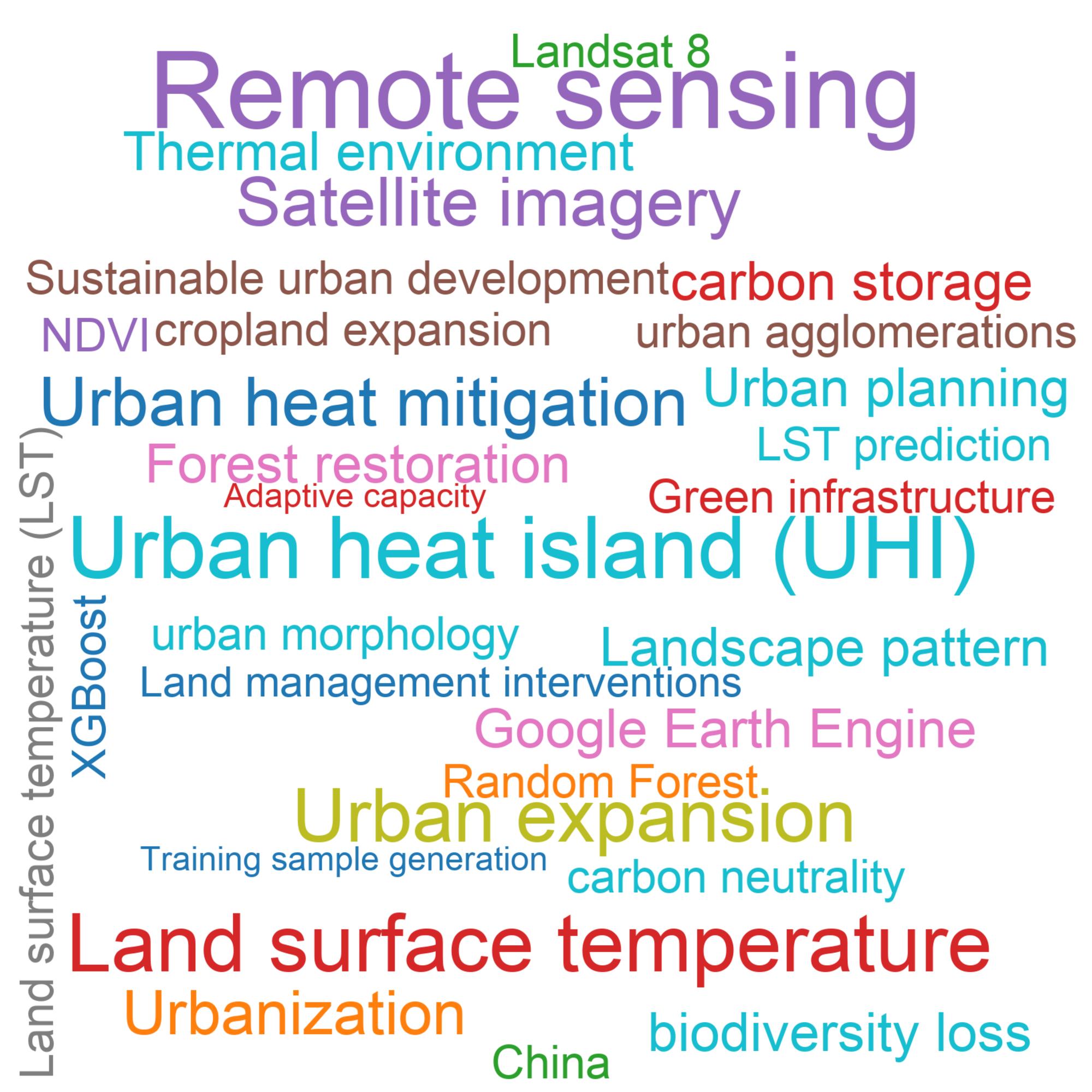
What Topics Define the Class of 2026?
The Class of 2026 for Land Use and Ecosystem Services is heavily focused on geospatial analytics, with 'Remote sensing', 'Urban heat island (UHI)', and 'Land surface temperature' emerging as the most dominant themes. The prominent use of satellite imagery enables nuanced spatiotemporal analysis of environmental changes. This trend suggests a broader transition from theoretical models to large-scale, data-driven observations, giving researchers new tools to evaluate human impacts on delicate ecosystems.
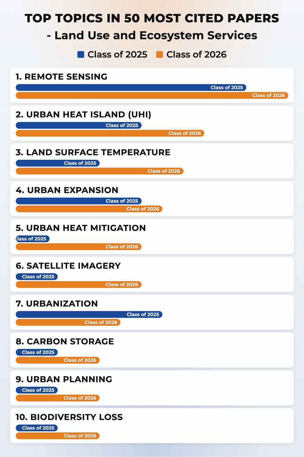
How Did Topics Shift from the Class of 2025 to the Class of 2026?
Analysis of cohort shifts reveals a clear move toward applied mitigation and predictive models. 'Urban heat mitigation' and 'LST prediction' represent the most significant risers, highlighting an urgent focus on developing actionable interventions for global warming. Conversely, general themes like 'Urbanization' and basic 'Agricultural land conversion' have decreased in relative prominence. This indicates that the research field is advancing beyond simply documenting land use change toward exploring specific, technology-assisted sustainability and resilience strategies.
Methodology
PRI identifies high-impact research using a transparent, topic-agnostic framework applied consistently across scientific domains. Bibliographic records are drawn from OpenAlex, including publication dates, citation relationships, and document types.
This ranking covers the Class of 2026 cohort: journal articles published in 2024. Reviews and other non-article document types are excluded to ensure comparability.
Research impact is quantified with an 18-month post-publication citation window—the number of citing works published within 18 months of each paper's publication date. This metric captures early impact while controlling for publication age.
An LLM-based relevance classifier then reviews each candidate's title and abstract to confirm substantive alignment with the target domain. Only papers classified as relevant appear in the final ranking.
Zheng Su, Tinsley Li, Thematic Shifts in Early-High-Impact Cancer Genomics and Diagnostics Research: A Bibliometric and Semantic Analysis. bioRxiv 2026.07.04.736459; doi: https://doi.org/10.64898/2026.07.04.736459
Cite this ranking
Pepkio Research Index (PRI). Topics and Trends in Most Cited Land Use and Ecosystem Services Papers, Class of 2026. https://pri.pepkio.com/top-papers/land-use-and-ecosystem-services/2026. Accessed 2026-10-24.

Methodology
Zheng Su, Tinsley Li, Thematic Shifts in Early-High-Impact Cancer Genomics and Diagnostics Research: A Bibliometric and Semantic Analysis. bioRxiv 2026.07.04.736459; doi: https://doi.org/10.64898/2026.07.04.736459
Source data
The full ranking corpus and analysis files are openly available on an external repository. Please cite the dataset below when reusing this data.
View source dataset →Pepkio Research Index (2026). Top Papers in Land Use and Ecosystem Services. [Data set]. Figshare.